
“Road trippin’ with my two favorite allies,
Fully loaded we got snacks and supplies.
It’s time to leave this town,
It’s time to steal away.
Let’s go get lost,
Anywhere in the USA”

Songs have paid tribute to the American road trip for decades. From Route 66, a Nat King Cole hit in 1946, to Road Trippin’ by the Red Hot Chili Peppers (quoted above), musicians have found inspiration in the vast open road connecting the Pacific Ocean to the Atlantic.
Road trips are so popular that the US Department of Transportation has designated 150 roads as scenic byways, promoting them as “gateways to adventures where no two experiences are the same.”
This summer we explored Utah’s Scenic Byway 12, a 124-mile highway which meanders through two national parks, three state parks, a national forest and a national monument. Scenic Byway 12 starts in a desert dotted with rock formations known as hoodoos and ends in a chilly woodland forest brimming with deer. In a nod to the diverse habitat, we spotted a rattlesnake and a mountain lion in the same day.
While the highway passes through rugged landscapes, it is paved and fairly smooth, meaning you don’t need a fancy four-wheel-drive vehicle to make this journey. Read on for the highlights of our three-day road trip across Scenic Byway 12.
1. Hiking in Zion National Park

One of Utah’s top tourist attractions, Zion National Park is not officially on Scenic Byway 12 but is the reason most visitors come to the region. Zion offers spectacular views, affordable camping and challenging hikes; if you are road tripping through southern Utah, make sure to allot at least two days to explore the park. You may even come across a rattlesnake, like the one we saw on the Watchman hiking trail (above).
>> Recommending reading: Hiking the Narrows at Zion National Park and Angel’s Landing: Utah’s scariest hike?
2. Leaving Zion
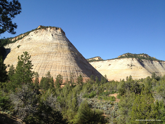
The road from Zion to Bryce Canyon National Park begins with a stark desert landscape. Multicolored mountains like the Checkerboard Mesa (pictured here) dot the highway and put Argentina’s famed Cerro de los Siete Colores to shame. We were so taken by the scenery that we stopped several times to snap photos. Little did we know that this area would pale in comparison to the views further east on Byway 12! The highlight of this stretch of road was passing through a tunnel that had actual windows carved into its side, presumably to allow for scenic viewing while driving. The feature was a bit distracting but made the tunnel feel less claustrophobic than most.
>> Recommending reading: Checkerboard Mesa information on Utah.com
3. Mormon history in Cannonville
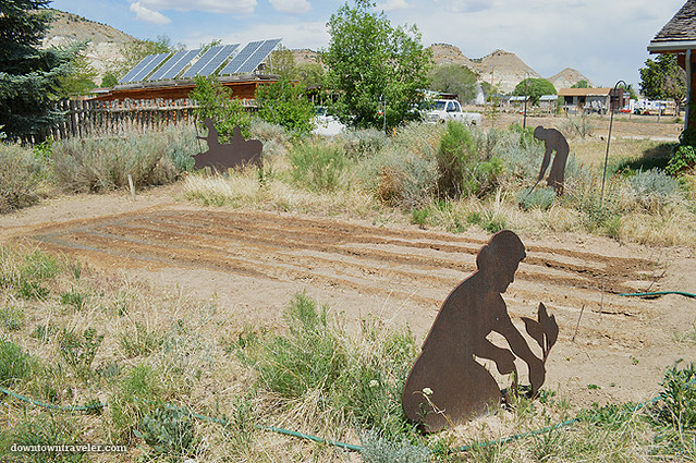
We breezed by many small towns on the way to Bryce that were little more than a cluster of homes circled around an American flag. A sign for the Cannonville Visitor Center caught our eye and we decided to pop in for a restroom break. The landscaped grounds contained exhibits about the Mormon pioneers who settled in the region; based on the metal sculptures on display, they seem to have dedicated a huge chunk of their time to hauling water from distant streams. The center was surprisingly large, immaculate and empty of visitors, making it easy to immediately speak to a staffer (who informed us that there was very limited camping available due to the annual Astronomy Festival in Bryce). Cannonville Visitor Center is a pleasant place to take a break from driving and to pick up brochures on the Scenic Byway.
>> Recommended reading: Cannonville Visitor Center page on the Bureau of Land Management website
4. First taste of Dixie

When red rock formations began to appear at the side of the highway, we were certain we had reached Bryce Canyon National Park. Surely these must be the hoodoos we had heard so much about! Doubts began to creep in when we noticed a sign bearing the name “Dixie National Forest”– and our suspicions were confirmed when we spoke to another couple at a roadside stop. They saw us snapping photos and urged us to save our memory cards since this was just a taste of what we would see in Bryce. It turns out we had entered the Dixie National Forest, a nearly-2-million acre preserve that stretches across southern Utah. We entered and exited the forest several times while traveling across Scenic Byway 12 and saw a range of wildlife there– from deer to a mountain lion (scroll down for details).
>> Recommended reading: Dixie National Forest official website
5. The big city? Reaching Bryce Canyon
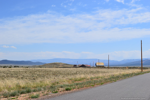
Bryce Canyon City is the first major town on Scenic Byway 12 but is hardly a bustling metropolis. The local airport resembles a tin shack and is only identifiable from a hand painted sign on the roof (pictured above). Before hitting the city center, and I use the term loosely, we barreled down a desolate stretch of highway that was straight out of an apocalypse movie. Our car whirred past a few motels (with signs flashing “vacancy” and no cars outside), houses strewn with children’s toys, and stormy skies stretching over farmlands. It was a surprise to hit the bustling town center in Bryce, which is known as the home of Ruby’s Inn, a historic hotel opened in 1923. Ruby’s seems to have a monopoly on local businesses; its empire includes a namesake hotel, the nearby Best Western Plus Ruby’s Inn (where we spent a night), a campground, a general store, an “old town” attraction, guided ATV tours and horseback riding. Billed as the “closest lodging” to Bryce Canyon National Park, the Best Western Plus Ruby’s Inn was a great place to spend the night before waking up early to explore the park.
>> Recommending reading:Ruby’s Inn Official Website
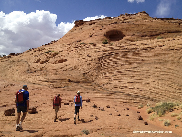
6. Hiking in Bryce Canyon National Park

When Jake’s mother heard we were visiting Bryce Canyon she had one piece of advice: make sure to blast classical music on the radio as you enter the national park. We heeded her suggestion and caught our first glimpse of the famed hoodoos (bizarre rock formations caused by wind and rain eating away at limestone) while listening to the strains of violins. I can’t remember the name of the composer or orchestra, but Sirius radio’s classical music channel provided a suitable soundtrack!
Make sure to have ample space on your camera’s memory card when you arrive at Bryce, which is hands-down the most beautiful national park I have ever visited. We had the chance to get close to the rock formations on a day hike that brought us down through the canyon, into a forest, and back up to the mountain top. Bryce has many self-guided hiking trails that range from easy (a paved walk along the canyon’s rim) to strenuous. The relentless sun and high temperatures are challenging, so make sure to bring plenty of water before setting out on a hike. We recommend the “Figure Eight,” which is grueling but provides a real sense of accomplishment at the finish.
>> Recommending reading: Bryce Canyon National Park official website
7. Exploring the Petrified Forest
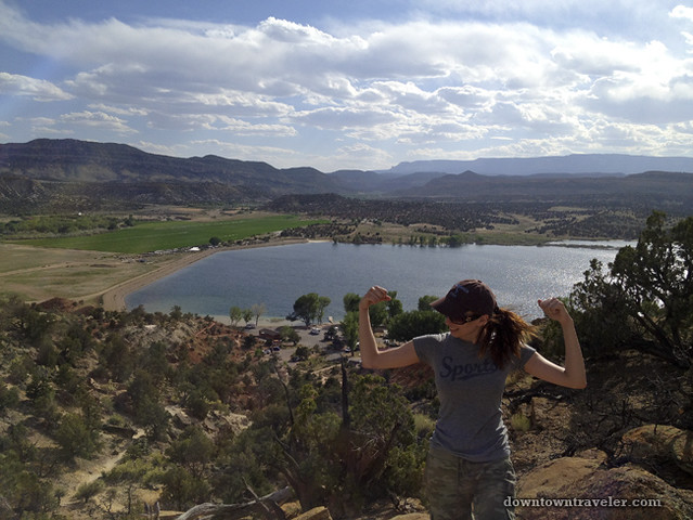
Our next stop on Scenic Byway 12 was the small town of Escalante, Utah, which serves as the gateway to Grand Staircase-Escalante National Monument. This is a great base of operations for adventure travelers, as several hiking trails start in town (or close by) and at least two canyoneering outfitters operate on Main Street. After checking in to the Circle D, a cute motel that was highly recommended on Trip Advisor, we drove to the Escalante Petrified Forest State Park for an afternoon hike. Located just 44 miles from Bryce, this state park has a totally different landscape. Hoodoos were replaced by a giant lake, rolling hills and an ancient forest. The 1-mile round trip hike starts with a fairly easy ascent up the side of a mountain (the trail is not paved, earning it “moderate” status), and plateaus in an area dotted with petrified wood. I’d hardly call this a “petrified forest,” since it houses a smattering of small, fragmented petrified wood. However, we did see a large tree trunk with well-preserved rings, which was millions of years old. If you visit the petrified forest, make sure not to take any specimens with you. As a sign at the trail head warns, this will bring you years of bad luck!
>> Recommending reading: Grand Staircase-Escalante National Monument on TripAdvisor
8. Playing in the Devil’s Garden

We heard of another self-guided hike with amazing views just outside of Escalante and couldn’t resist a chance to see more hoodoos. The Devils Garden is one of the first stops on the historic, 57-mile “Hole in the Rock” road first traversed by Mormon pioneers. We opted not to drive the full length of the road, which is a six hour round-trip over a corrugated (i.e., very bumpy) road. The Devils Garden is part of the Grand Staircase-Escalante National Monument and both entry and parking are free. The sandy trails are relatively flat and make for an easy hike (or more accurately, walk). If you are visiting Escalante, the Devils Garden is a must-visit!
>> Recommending reading: Hoodoos and Scenic Views at Utah’s Devils Garden
9. Canyoneering in Escalante National Monument
Prior to our trip down Scenic Byway 12, our only experience with canyoneering was watching the film 127 Hours, in which James Franco plays a real-life adventurer who gets pinned under a rock during a Utah hike and has to sever his own arm. Needless to say, we had some reservations about trying the sport!
On the advice of the Garfield County Tourism Council, we booked a guided day trip with Excursions of Escalante, a locally-owned outfitter. Our guide, Jim, led us to a remote part of the National Monument (we actually had to sign an NDA stating we would not reveal the exact location), pointed to a sheer cliff and matter-of-factly mentioned that we’d be rappelling down the canyon. My heart began to palpitate as I crawled down the mountain on my butt, gripping the rock below me, and spotted a boulder with a rope tied around it. Before I could run back to the car, Jim attached me to the line and encouraged me to walk backwards down the cliff. It was incredibly scary, but after completing this initial obstacle I was desensitized to the heights and gladly scampered down, over and through the slot canyons with and without a harness. The canyoneering trip was one of the highlights of our action-packed journey through Scenic Byway 12.
>> Recommending reading: Excursions of Escalante website
10. Jurassic Park views (minus the danger)

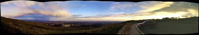
A father-daughter duo we met on the canyoneering excursion had made the Scenic Byway12 trip from the other direction– east to west– and told us the views from Escalante to Boulder were the most beautiful. They recommended we allow enough time to stop and savor the rolling mountains and valleys, instead of rushing to get to the next town. We headed east as soon as we finished the canyoneering trip and hit this stretch of highway just before sunset. Our fellow travelers did not lie: this unique landscape would look at home in the film Jurassic Park. We stopped at the side of the road every few minutes to snap photos of lush green trees, multicolored mountains and a creek. This was the most winding section of highway– make sure to stop for photos only when there is a shoulder or look-out point. The parking lot at the Kiva Coffee Shop offers some of the best views.
>> Recommended Reading: Kiva Coffee Shop website
11. Fine dining in Boulder
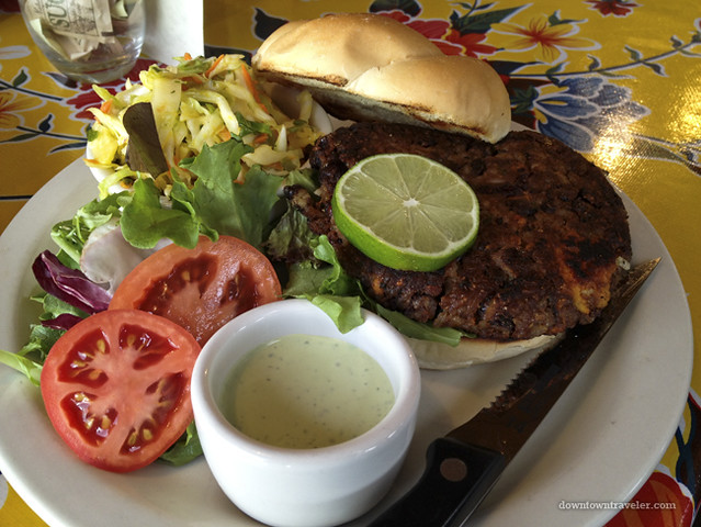
Annie, an owner of Excursions of Escalante, recommended we dine at the Burr Trail Grill in Boulder– one of two competing cafes in this tiny mountain town. Owned by a young couple, the restaurant boasts local ingredients and surprisingly innovative dishes. We feasted on fried polenta, “chop” salad (a vegetarian Caesar), a veggie burger made of sweet potato and beans and, of course, a homemade peach pie. The delicious food, craft beers and down-home decor (checkered table clothes, pie counter) reminded us of a trendy Brooklyn bistro. The prices were also reminiscent of New York ($60 for the above-mentioned dishes) but this was the best meal we had on the entire trip!
>> Recommending reading: Burr Trail Grill on Yelp
12. Chasing cougars in Dixie National Forest
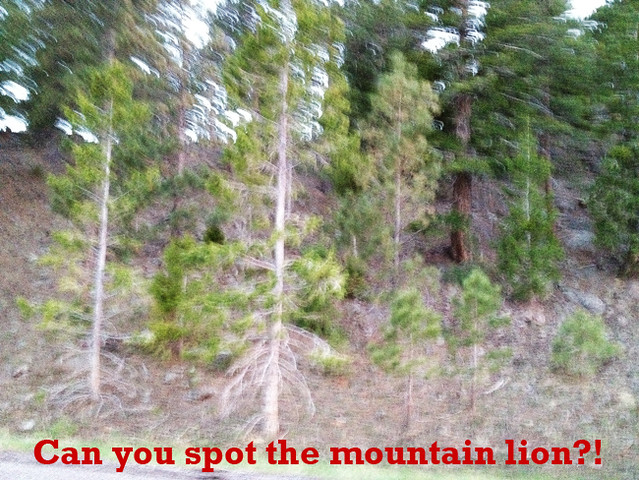
We left Boulder just before dusk and found ourselves entering the Dixie National Forest once again. This time the forest was heavily wooded, and the temperature dropped so suddenly we had to pull over and put on sweatshirts. Driving the Scenic Byway around sunset was perilous, since deer began to come out of the bush and graze on the side of the highway.
I was writing in my travel journal on a remote stretch of Byway 12 when Jake shouted “Is that a cougar?!” I looked up to see a dark gray form slinking across the highway directly in front of our car. Its head was bowed and it seemed to be stalking prey. Unfortunately, it disappeared in the few seconds it took me to grab my iPhone, so I only captured a blurry photo of the forest (above).
We were incredibly lucky to see a mountain lion. This native species is so rare that hikers are advised to report any sightings to authorities.
>> Recommending reading: Wikipedia page on Cougars (Mountain lions)
13. End of the line
The mountain lion sighting was the climax of our Scenic Byway 12 journey and marked a swift end to our good luck. We drove in total darkness to Torrey, gateway to the Capital Reef National Park, going incredibly slowly to avoid the rabbits, deer and other critters that kept darting across the road. We arrived in Torrey to discover that every single hotel room was booked due to a motorcycle rally. Since we didn’t want to camp in freezing temperatures, we ended up driving half way to Salt Lake City that night. This taught us a crucial lesson: if you really want to spend the night in a small mountain town during peak tourist season, it’s best to book your lodging ahead of time!
Driving Scenic Byway 12 was an amazing experience. From desert rock formations to chilly woodland forests, we experienced a wide range of climates in just three days. We visited two national parks, overcame our fear of heights to rappel down a canyon and saw America’s most exotic wildlife.
Three days is barely enough to scratch the surface of this beautiful stretch of southern Utah. I look forward to going back one day to see Capital Reef and to finally capture a photo of the elusive mountain lion.
***
Have you driven Scenic Byway 12?
If so, please share your experience by leaving a comment below! If you are reading this via RSS or email, please click on DowntownTraveler.com to leave a comment.
We traveled independently across Scenic Byway 12, receiving helpful advice (but no compensation) from the folks at the Garfield Country Tourism Office. Excursions of Escalante provided us with a complimentary canyoneering trip in order for us to write a review, and we received a discounted media rate at the Best Western Plus Bryce Canyon.
I am totally convinced that this was a great road trip, particularly because it was to one of my favourite places in the USA. Lucky you. We’d certainly plan a longer stay in Utah next time we visit.
Reply
Definitely spend a few days crossing Scenic Byway 12 the next time you are in the Southwest. It was unbelievably gorgeous! These photos don’t do it justice. And the hiking at Escalante-Grand Staircase was awesome 🙂
Reply
Who would have known there’s so much to see in Utah’s byway 12?? You made the adventure sounds so exciting! I must plan a trip to visit the US very soon!! 🙂
PS: Thanks for making me the featured writer!!
Reply
Thanks! Southern Utah is a beautiful part of the US. Can’t wait to go back 🙂
Reply
You two have been on some great trips. Love seeing your pictures (adventures!). Thanks for sharing these.
Reply
This was a fantastic road trip! It would be great for families too– it has the comfort of being in the US with a very exotic landscape 🙂
Reply
I have never heard of Scenic Byway 12 but this looks like a fantastic road trip and it covers all the National Parks that I am dying to visit in Utah! Thanks for sharing and I will bookmark it for our next big road trip 🙂
Reply
Definitely check it out! It’s a classic US road trip 🙂
Reply
They say Bryce Canyon was found when a rancher’s cow wandered down into the canyon and got lost.
Reply
What a lowly beginning for a breathtaking national park!
Reply